Showing posts with label National Monument. Show all posts

Coolidge,AZ - Casa Grande National Monument


Nestled in the Sonoran Desert near Coolidge, Arizona, Casa Grande Ruins National Monument is a doorway into the ancient past. As a travel writer, I was captivated not only by the iconic “Great House”—a towering four-story adobe marvel—but also by the rich history and enduring spirit of the landscape and its people.


🏜️ A Monument Steeped in Time

The Great House, constructed around 1350 CE, dominates the site with its caliche walls—Adobe crafted from desert subsoil hardened over centuries  . The structure is surrounded by a bustling Hohokam agricultural community that flourished from around 1150 to 1450 CE, sustained by an ingenious system of irrigation canals tapping into the Gila River  .


Archaeologists believe Casa Grande served multiple roles: a ceremonial observatory aligned with solar and lunar events, a gathering spot, and a central node in a thriving trade network . While the Hohokam mysteriously abandoned the site around 1450 CE, descendants in the O’odham, Hopi, and Zuni tribes maintain enduring cultural connections.


📜 From Protection to Preservation


Remarkably, Casa Grande was the very first archaeological reserve in the United States, set aside in 1892, and later designated a National Monument in 1918  . Over time, efforts to stabilize the Great House culminated in the iconic protective canopy designed by Olmsted Jr. in 1932—a steel ramada that helps preserve the fragile walls from erosion  .


What began as early conservation has evolved into a site where interpretive exhibits, guided tours, and ranger programs bring the human story vividly to life.


🎒 A Day in the Desert

Just 20 minutes from Interstate 10, the park is refreshingly accessible—no entrance fee and open daily, though seasonal hours differ slightly  . A typical visit spans around two hours, and here’s what makes it special:


  • Visitor Center & Museum: Hands-on exhibits, artifacts, traditional baskets and pottery, plus a short film detailing Hohokam life and the site’s significance  .
  • Guided Tours & Ranger Talks: Discover astronomy, engineering, and cultural insights through engaging park staff-led sessions  .
  • Trail Around the Ruins: Photo opportunities abound around the Great House. You’ll also find a ballcourt, compound walls, and an interpretive trail through native plant gardens  .
  • Operate with Care: Mornings or cooler months offer more pleasant conditions. Shade is scarce, so bring water, sunscreen, hats, and maybe even an umbrella .

During my visit, midday desert sun scorched the fields, but refuge under the ramada revealed fine masonry details, horned-owl nests tucked in rafters—a delicate balance of nature and history preserved over centuries  .

🌿 Beyond the Ruins

Coolidge makes a charming gateway town—stop at local cafés or drive through cotton fields nourished by the same ancient irrigation methods  . Nearby, the Gila River Indian Community and Huhugam Heritage Center showcase tribal crafts, oral histories, and cultural events  .


For travelers crafting a Southwestern itinerary, Casa Grande sits perfectly between Phoenix and Tucson—an enriching stop alongside destinations like Saguaro National Park, Tuzigoot, and Montezuma Castle  .


✨ Why It Resonates


Casa Grande isn’t just an archaeological marvel—it’s a vibrant intersection of past and present. It invites us to reflect on human ingenuity able to shape community and infrastructure in unforgiving terrain. Today, it connects us to the Sonoran Desert’s original inhabitants and their descendants, who carry forward its story.


📝 Travel Tips


Tip

Details

Best Time to Visit

Morning or off-season to beat heat

Essentials

Water, shade, hat, sunscreen, camera—don’t leave the umbrella!

Visitor Center Hours

9 AM–4 PM (summer) or 9 AM–5 PM (winter)

Admission

Free

Suggested Duration

1–2 hours; longer with tours

Nearby Stops

Huhugam Heritage Center, Coolidge, cotton fields, Sunrise/Sunset views


Final Thoughts


Walking amid the echos of this thousand-year-old community, I found Casa Grande sudden yet calm, both historian and poet. Here’s a place that challenges us to think across time: about the desert’s thirst, communal vision, and the people who live on. It’s a moment of both awe and connection—a must‑experience when journeying through Arizona’s cultural and natural heart.


Rimrock, Arizona - Montezuma's Well

Montezuma's Well is located east of Interstate 17 in Rimrock, AZ.  Take exit 293 and drive through McGuireville (stop at Nikki's Grill for a great meal) and Rimrock.  The location is well marked with signs.  Also, there is a really nice picnic area, so remember to pick up a lunch at Nikki's.

The Well is not considered "accessible" as there are steps and rough paths.  I only had time to walk the upper path.  There is a continuation of the path that winds down the hill to the creek and returns to the parking lot.

The information that I provide on this page was taken from the Park Service's information displayed around the area. The internet has many more details if you are interested.


 There is no cost to enter. A donation is appreciated. Find the red box near the path exit.  It is across the parking lot near the restrooms.  This building is the office.
 Rocks layer on either side of the path.
 This is my first peek as I approached the first view point.
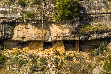
 The Sinagua (name means without water) cliff dwellings.

 Looking down at the Well.

 There are no fish in the well due to water conditions.  There is plant growth.  Life in the Well consists of leeches, amphipods, water scorpions, and turtles.  The water is highly dissolved concentrated carbon dioxide (more than 600 times the normal level).

The next photos are views of the beautiful clouds and wildflowers.


 The well is a sinkhole, a collapsed underground cavern filled with water.  More than a million gallons of water flow through the well a day.


 A distant storm verga across the valley.

 Reflections of the cliff dwellings in the Well water.

 Some housing ruins.
 An old tree.

 Cactus in bloom.  Don't get too close!
 Ancient trenches carried the water from the well to the cultivated areas.

 The well is 368 feet across and 55 feet deep.  The panoramic pulls the views together so that you can see the entire area.  I am standing at the far lookout. Across the pond are the cliff dwellings.
This ends the views of Montezuma's Well.  We went to the picnic area and enjoyed lunch.

On the way home I stopped at Sunset Point and took a few more photographs.  There was a storm over Bumblebee (the town below the lookout).
 The rest stop had several desert plants in bloom.  I am waiting for the arrival of my new Savage micro lens set but decided to capture some desert color to share.


Marble Canyon, Arizona - Hoodoos

In this area, the Hoodoos are large rocks that have tumbled down from a nearby cliff, landed in the valley below, and have had the ground underneath them gradually washed away.

These are located in a pull over area, complete with diagrams and more information, on the road to Lees Ferry from 89a.


 To give some perspective as to the size, compare the size of a fellow photographer to the rock.
 The morning sun is beginning to shine through the clouds and light the cliffs.

Marble Canyon, Arizona - Vermilion Cliffs National Monument

The Vermilion Cliffs National Monument is located in the upper northern part of Arizona on the Colorado Plateau.  This wall of cliffs extends for miles.  The area is a remote and unspoiled 280,000 acre geologic treasure.

This panoramic was taken at a pull over spot on the road that descends to Lee's Ferry from 89A.


Flagstaff, Arizona - Walnut Canyon National Monument

Dwellings sheltered by overhanging cliffs were home to Walnut Canyon's only permanent inhabitants more than 800 years ago.  The people are today known as Sinagua (Spanish for "without water"). [Source: Park brochure]

There is a Visitor's Center and a $5 entrance fee.  The top portion of the main view point is accessible, and the hiking pathway leads to a wonderful close-up view, complete with about 240 steps.

This is the panoramic from the Visitor's Center.


 San Francisco peaks with snow capped tops.


There is a "Rim Trail" that has a nice paved pathway and is accessible.  The walk to the farthest lookout point is about 1/4 mile.
 This is from the first lookout point:
 You can see the hiking path in the center to the left of the large rock formation.
 A view of the surrounding ponderosa forest.
 Scattered dead trees add to the view.

 Arizona wild flowers abound.
 Seating benches are placed along the path.

 There are informational signs along the way identifying the plants.  I liked this one because the curly grasses caught my eye.  Blue Grama: "The root of the "curled up grass" is used in Navajo Life Medicines, concoctions of several plant parts known to have special healing powers.  Stems can be fill in Hopi coiled baskets.  But the most widespread duty has been as a hair brush, made from the cut ends of a bundle of stems.  The soft ends served as a broom."


 Other flowers dotted the landscape.

 A view of one of the walls,  You can see the walkway and terraced home areas.

The panoramic from the third viewpoint:


 I liked these big boulders.  The photo is level...the land is not!

I took some panoramic shots so that you could see the entire view.

Why Are There So Many British People in the Dordogne?

  Why Are There So Many British People in the Dordogne? What you have noticed around Château Marouatte is not incidental. The Dordogne has ...